Austin Peay State University led face shields project joined by International consulting firm Ankura
April 29, 2020
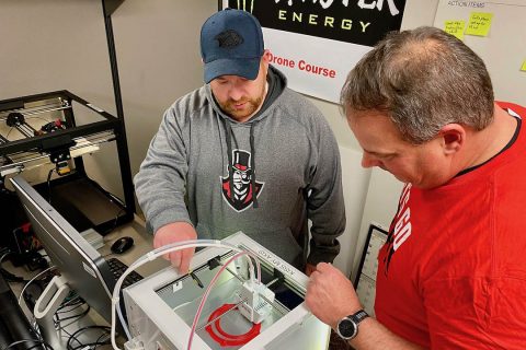
 Clarksville, TN – The Austin Peay State University (APSU) GIS Center has been joined by Ankura, an expert services firm with an office in Nashville, in a statewide effort to produce face shields for frontline medical workers during the coronavirus crisis.

The Austin Peay State University GIS Center leads a statewide effort to produce face shields for medical workers. (APSU)
APSU GIS student’s road closure map unveiled on Clarksville’s new website
April 17, 2019
Austin Peay State University (APSU)
 Clarksville, TN – When the City of Clarksville launched its new website on April 8th, 2019 that day’s news release lauded “a fresh, easy-to-navigate and more powerful website that will enhance the city’s ability to engage and serve its citizens.” Austin Peay State University’s GIS Center helped create one of the engaging elements that lives on the city’s new homepage – an interactive map that continuously updates with road maintenance and closure information.

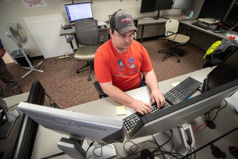
Bryndon Rhoton, a computer information systems junior at Austin Peay State University, designed the road closure map on the City of Clarksville’s website.
Live APSU Peay Pick Up location information now available on Peay Mobile 4.0 app
August 28, 2015
 Clarksville, TN – Anyone with a smartphone or internet-connected device can now get real time information about Austin Peay State University’s Peay Pick Up trolley system through the University’s Peay Mobile 4.0 app.
Developed by APSU students, the new feature can show the trolley’s location around the University campus, with the position updated every 15 seconds. The feature is accessible in APSU’s new Peay Mobile 4.0 app, which was redesigned in June.
AP Mobile 4.0 is free and can be downloaded by visiting www.apsu.edu/mobile
APSU Students conduct research on different GPS devices accuracy for field purposes
December 4, 2012
Austin Peay State University
 Clarksville, TN – Late last year, a group of Austin Peay State University geosciences students hiked through the woods in rural North Carolina, conducting field research.
They were looking for unusual rock outcroppings, and after each discovery, the students painstakingly scribbled down the longitudinal and latitudinal coordinates of the rocks into their notebooks.
That is, except for APSU student Maurice Testa. He simply pulled out his smart phone and quickly went to work.

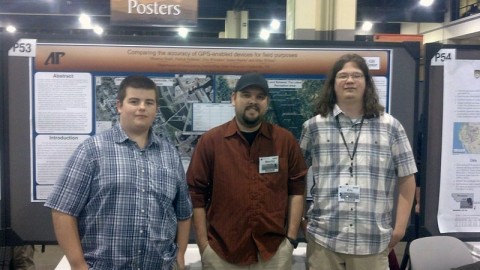
APSU students James Martin, Maurice Testa and Eric Whitaker stand before their poster at the Geological Society of America meeting.
APSU faculty, staff, student accomplish various work
May 14, 2011
 Clarksville, TN – Faculty, staff and students at Austin Peay State University recently achieved various accomplishments for various professional and scholarly work.
Mike Wilson, director of the GIS Center at APSU, and Doug Catellier, GIS analyst, showcased the center’s Disaster Mitigation and Recovery Kit (DMARK) at the U.S. Department of Homeland Security Science and Technology Expo in Washington, D.C. They also met with various congressional aides as well as officials from FEMA and the Department of Homeland Security to discuss their project. [Read more]
APSU’s GIS Center and Oak Ridge Receive $400,000 Grant for Cell Phone App Program
April 14, 2011
 Clarksville, TN – On a stormy Monday afternoon, while tornado sirens blared across the Austin Peay State University campus, Mike Wilson, manager of the school’s Geographic Information Systems Center, decided to talk about natural disasters.
“Suppose a tornado rips through here,” he said, knocking on his wood desk to ward off the suggestion. “If that happens, local officials will need to do a preliminary damage assessment. That’ll go to the state, and the governor will make a decision on whether to call in FEMA for a natural disaster. This app speeds that up.”
Wilson motioned to his Android mobile phone. A year ago, his office, in conjunction with the Oak Ridge National Laboratory, developed an innovative new cell phone application known as the Disaster Mitigation and Recovery Kit (DMARK). The application allows emergency responders to document immediately any damage they come across following a disaster. [Read more]
APSU GIS Center helps develop Damage Assessment application
May 27, 2010
 The building, like so many homes and businesses in middle Tennessee, was a pale brown from where the floodwaters covered it. Mike Wilson, manager of Austin Peay State University’s Geographic Information Systems, stood among the tree limbs and other debris in the Woodlawn community and pulled out his cell phone.
He wasn’t making a call. He was filling out a damage assessment of the property and filing it to an electronic server. It took him only a few minutes to complete. For years, the long, drawn-out process of recording the destruction inflicted by a disaster has sometimes taken days or weeks, delaying the time it takes for needed aid to reach an area, but a new cell phone application, developed by the APSU GIS Center and the Oak Ridge National Laboratory, may soon allow emergency responders to document immediately any damage they come across. [Read more]


